This story was written for T3 Magazine, and originally appeared in February 2001; reprinted with permission
On paper, the assignment looked simple enough, yet it still scared me. Who the heck heads off into the remote, high desert of Southeastern Utah at the start of winter with more weight in tech gear than camping equipment?
Yet that’s exactly what T3 wanted me to do. In fact, they even labeled the assignment “Survivor,” which, despite the positive spin, made me wonder exactly how close the editors thought I might come to the opposite scenario, as in “Deceased.”
The basic premise was to set up a scavenger hunt in the maze of canyons outside Capital Reef National Park in Southeastern Utah. The checkpoints and rewards—including all the food and water I’d need to survive—could only be found by using a gaggle of electronics: GPS units, altimeters, digital compasses, cellular and satellite phones, two-way radios, and even a pedometer. And while traveling over this course, I also needed to keep a digital diary using my Palm IIIc and Nikon Coolpix 990. Oh, did I mention that I also needed to find the starting point using a rented Ford Explorer equipped with Hertz’s Neverlost navigation system?
My first thought was that I was going to die due to a lack of lithium. As in lithium batteries. With temperatures in the area forecast in the twenties, all this electronic gear was likely to chew through a dozen pounds of batteries. I could end up looking for my water supply with dozens of blank LCDs.
Worse still, my last phone conversation with Tim, the owner of the Utah-based outfitter setting up the challenge, revealed another problem I’ll face.
“GPS hasn’t been very reliable in the area you're going lately,” Tim tells me. He makes this scary statement the same way some people tell you the time. A seasoned trip guide, Tim makes everything sound matter-of-fact, even when it isn’t. I decide that he must be from Maine. I can almost hear the “ah-yup” at the end of each sentence.
“I’ve been getting readings as much as a 100 yards off,” Tim says.
Yikes. 100 yards can mean the difference between being entering the right canyon or the wrong one. Suddenly, I have a very unsure feeling about what I am getting myself into. I wonder who’ll discover my body next spring.
Okay, I’ll admit that last sentence is a bit over the top. I’m actually a skilled backcountry veteran who’s taken survival courses, has all the right gear and apparel, and who is certified to practice Wilderness First Aid should I come across a stray injured body deep in the wilds. Couple that with 20 years in the high tech industry, and, yes, I should be able to stay alive for three days while navigating with whatever user interface some city-bound engineer had kludged up.
Nevertheless, I fret about the difficulty in completing the assignment as I step off the plane in Salt Lake City. I’m “flying on instruments only” from this point forward. Long ago, I learned that electronic tools can mislead and sometimes make tasks harder.
Case in point: I need to pick up some fuel for my stove, so my first chore is to enter the local REI store into the Hertz Neverlost as my first destination. Unfortunately, typing on the Neverlost is done using only arrow keys. I spend more time entering the street address than it took me at the rental counter to acquire the vehicle. I wonder how well my mother would do on this task. I decide she’d probably still be sitting in the parking garage pressing buttons.
Programming complete, a sultry feminine voice suddenly speaks up.
“Please proceed to the highlighted route,” she says. Okay, I can do that. I decide to call my newfound companion Neve.
I pull out of the dim confines of the Hertz parking garage into a blinding sun. Yee-haw. The weather has finally cleared after a week’s worth of storms. While I don’t dislike hiking in rain, it does add a complication I could do without on this trip. Neve informs me to take the on-ramp onto Highway 80. I was a happy about-to-be camper.
Wait a second. Highway 80?
I look down at the route Neverlost indicates. Doesn’t it know about the frenzied pre-Olympic road construction going on in Salt Lake City? These days Highway 80 no longer crosses town, and both Highway 15 and 215 have numerous ramp closures and detours. Sure enough, I come to the end of the navigable portion of Highway 80, but Neverlost blissfully shows me continuing on. Okay then; let’s see what happens when I pull off into the city streets.
“Please proceed to the highlighted route,” says Neve.
Yeah, right. I’ll just grab a bulldozer and join the construction crews. Since I know Salt Lake City’s layout pretty well, I head towards where I think I can get onto 215 South. After a couple of repeats of the “please proceed” message, Neverlost decides I have abandoned the old route and starts calculating a new one. Cool.
Everything goes swimmingly until nearly four hours later I arrive at an agreed upon spot near Capital Reef National Park. The display suddenly shows the satellite acquisition screen (“1 Satellites located…”), and Neve has gone silent, clear indications that the GPS system has lost contact with some of the satellites it relies upon to track position. Curiously, the Magellan handheld unit shows it is locked onto five satellites.
Fortunately, there really isn’t any way to get too far off track at this point. There’s only one road I can take and that’s the one I’m already on. My instructions tell me that the trailhead is “past the last commercial building in Torrey” and at UTM 42 41 715N and 46 7 453E. (UTM coordinates are one of several methods of tracking position. I specified UTM for the challenge since UTM values give you direct distances in meters. For example, the difference between 42 41 715N and 42 41 725N is 10 meters to the North. The Magellan Map 410 I’m using handles 12 different coordinate systems, and allows both a primary and secondary one to display, which is convenient if you’re moving between map-based coordinates and navigating by distance.)
Since Neverlost couldn’t find the trailhead, I open the sunroof on the Explorer—despite the subfreezing temperature—and drive the next stretch of road holding the Magellan upside down above the roof. With no one else on the road—who else would be foolish enough to go hiking on such a cold November day—I am able to drive slowly enough to let my eyes bounce back and forth between the empty road ahead and the GPS coordinates displayed by the Magellan.
250N and 400E. I am close, very close. And look, there on the right is a turnout. I pull off the road and get out to compare the instructions against the Magellan’s readings. I am less than a few meters off in one direction, but perhaps 400 meters off in the other. I look up the road. Is that another turnout ahead?
Back in the Explorer I resolve to drive a half-mile, then stop and recalculate. I’m doing my own crude form of triangulation.
In this short stretch of road I find three turnouts on the right and one on the left, all of which clearly have trails branching off them. None of the four possibilities match my instructions exactly, but it seems like the one on the left is closest. I pull in and for the third time in as many minutes take the time to let the Magellan get a clean reading from a fixed position. This has to be the place. Has to be. If my equipment is off by more than a few hundred feet, I’m in big trouble.
My instructions are to phone from the trailhead. I grab my Nokia 5160 cellular phone and call the outfitter.
“What do you see,” he asks.
“A pullout with what appears to be a very muddy doubletrack headed north,” I answer.
“Is that all?”
Oh-oh, I don’t like the sound of that question. I pause to take a closer look at my surroundings.
“Uh, well, there’s a fence about 50 yards in.”
“Walk to it and tell me what you see.”
After a few moments, I can answer: “a BLM trailhead sign that prohibits ATVs.”
“Congratulations, you’ve found the trailhead. Good luck.”
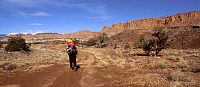
I look at the muddy single-track that heads gently upwards towards several banks of rocky cliffs. Doesn’t look too difficult. Even once the course goes off trail, this terrain looks passable, I think.
Of course, I am carrying a 60-pound pack, with over half of the weight due to electronic gear, batteries, camera equipment, and extra dry bags to protect everything. I’ve got a treasure trove of geek gear: Magellan Map 410 GPS, Motorola Talkabout TA280 SLK radio, Suunto Vector altimeter/compass/watch, Globalstar Qualcomm satellite phone, Sportline Fitness Pedometer 360, and much, much more [I've removed the How Does it Rate? sidebar to this story, as it no longer applies to gear you'd buy or use]. Not to mention three extra sets of batteries for everything except for my two phones, which use batteries I won’t be able to recharge or replace on the trip.
As I sit on the Explorer’s tailgate fueling up with a pre-hike guzzle of Gatorade, I am confident and happy. The rains that had plagued the area for the past week have lifted, the sun is out, and I am about to do one of my favorite things—hike into a beautiful and wild area of the country that few ever see. Of course, normally I’d leave most of the technology behind at the trailhead and just let nature wash over me as I navigated by map and compass. Today, however, about the only part of civilization I get to leave at the trailhead is the Ford Explorer.
Since the first three waypoints are to be found via GPS, I take a few moments at the trailhead to enter them as a “route” in the Magellan’s memory. By entering a route, I enable the unit to give me bearing and distance instructions relative to my ultimate destination. It takes me longer than usual to program the unit, as I had committed myself to that male habit of not reading the instructions that came with my equipment. It takes me a few minutes to realize that “Landmark” is the term Magellan uses for “Waypoint,” for example. (Curiously, when I accidentally set the unit to navigate on water, it starts using the term Waypoint!).
A glance at my multifunction Suunto Vector watch tells me it is already past 11 am and I am at 6700 feet. Time to get moving, otherwise any glitch in finding checkpoints might make me have to look for camp in the dark, something even the hardiest of hikers try to avoid. And since I hadn’t had a chance to acclimate to the altitude, I’ll probably be moving more slowly than usual.
Not quite knowing what to expect, I set out on what looks to be an established trail. Other than the ubiquitous mud, the walking is easy. I am a bit surprised to learn from the Sportline Fitness 360 pedometer mounted on my hipbelt that I am walking at 2.8 miles per hour. That’s faster than I would have expected, given how loaded down I feel.
Within minutes, forks start to appear in the trail. I let the Magellan pick a fork each time I encounter one, happy that, at least so far, every decision seems to be clear-cut. Sometimes the Magellan points a few degrees off the trail fork, but it always clearly favors one over another, so I am confident that I’m on the right track.
Some of the points on the Course have been given names by Tim. This first is labeled “Big Tree.” I wonder why he has taken the time to label this checkpoint. I can see quite a few large trees along the route. Is Big Tree something truly bigger than these, or is it simply one tree a bit bigger than the others? Given what little I knew about Tim, it could be either. Heck, I can even imagine him trying to fool me by drawing a Big Tree on the ground. I decide to trust the GPS instead of trying to second-guess Tim, but it still nags at me. Is that the Big Tree? Or is that Big Tree?
I feel a hot spot developing on my left heel, the precursor of a blister, but I decide it doesn’t warrant stopping. I’ll do something about it when I get to the checkpoint. I keep up my 2.8 mph pace, now with my eyes glued to the Magellan. Every once in awhile I look up to glare at a nearby tree and wonder if it is Big. Fifteen minutes of that, and I stop looking at the trees and just ponder the never-ending steam of information coming from the GPS.
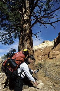
The hike is getting a little tedious when I suddenly realize that the coordinates on the Magellan are close to those in my instructions. I look up only to be startled by a massive Ponderosa Pine standing directly in front of me. This tree is far and above the size of anything else nearby. I walk over to it, scanning for a marker cairn. And, there, at the foot of the pine, is a small stack of rocks holding down a note telling me how to find the next point.
Big Tree meant Big Tree. Doh!
According to the pedometer, I’ve come over a mile so far (the Magellan agrees). And though mid-forties may seem cold to those of you reading this, when you’re trudging through mud with a 60-pound pack on your back in mostly shadeless terrain, you get hot. Time for a hydration break and the removal of some layers of clothing. Heck, and while I’m at it, let’s whip out the satellite phone and let Tim’s assistant, Steve, know I’m well on my way. Perhaps I am being a little cocky, too, needing to show off that my slight hesitancy in finding the trailhead was just a fluke.
The Globalstar phone makes an instant, clear connection.
“Hello from Big Tree,” I say to Steve, who answers the phone as if expecting someone else.
“Hey Thom, good going. That was the longest leg of the course, but also the easiest.”
Oh. So much for cocky.
Reluctantly, I put my heavy pack back on and slog through some more mud.
The trail now deviates from the bearing the Magellan wants me to take. Of course, I can’t quite go the direct route it wants me to, as there is a hundred-foot, unclimbable bluff in the way. I have to make a decision on how I am going to get to where I think the next checkpoint might be.
In front of me are three distinct passages carved from the rock, sometimes referred to as “slots” or “canyons,” but in this case probably more correctly identified as a “deep wash.” These labyrinthine channels are carved out of the desert’s softer ground by the occasional flash flood. In some areas, the waterways narrow down into deep tunnels barely wide enough to pass (a slot). In others, they are large and have multiple paths along the bottom (canyons). From time to time, you encounter hard rock “pourovers” (dry waterfalls) that have to be climbed, or small banks that you have to scramble up. When the weather cooperates and a wash is “dry,” generally you just hike in the path of least resistance.
Since the Magellan points to the right, I decide to take the rightmost wash. This isn’t an automatic choice, though, as I have no idea where the top of this narrow passage lies. It could eventually curve far to the right, in which case the central passage might be the correct one. Or all three passages might eventually veer off to the left, meaning there was another path I should use. It’s now well past noon, so I don’t have time to reconnoiter, as I’ve only got a few hours of daylight left and many more checkpoints to find. With a gulp of doubt, I enter the wash on the right.
As the proverbial crow flies, I’m not making much progress. I make dozens of left turns and a like number to the right. In the softer passages the mud slows me to a crawl. I have no idea which way I’m headed. Every time I check the Magellan, it seems to be pointing in a new direction, and almost always at an unclimbable wall. Given Tim’s warning about his GPS giving inaccurate readings, I wonder again if I have picked the correct path.
After a half hour of bouncing off walls, I top out of the wash, not very far from Big Tree. I find that I’m on the edge of a bluff that overlooks the last checkpoint. The Magellan shows the next waypoint is up and to the right, but across terrain that I can walk cross-country. I breathe a sigh of relief. As it turns out, I chose the right wash.
Now I'm supposed to navigate by digital compass. Holding the Suunto Vector watch level so that it shows a heading is tiresome and awkward, but for the first time in an hour, I’m on terrain that is reasonably flat and not filled with mud. As I move towards a rocky ridge, the heading points just to the right of it. I note a couple of muddy footprints heading left. Since Tim and Steve have both told me not to trust footprints, I ignore the footprints and head northeast, to the right of the ridge edge.
I navigate a few hundred yards of tricky traverse along the side of the ridge before taking a new reading. I am off course. The waypoint lies on the other side of the ridge. Drat. Backtrack time. The sun is now beginning its slow dive for the horizon and I’m famished from carrying my overweight pack through so much mud. But if I stop to eat, I’ll lose precious daylight. I seriously consider using the Globalstar satellite phone to ask Tim or Steve for a clue, but my pride won’t let me. Instead, I down a handful of the “emergency gorp” (trail mix) I keep in my pocket, greedily suck down the last of my Gatorade from my water bottle, and continue on.
Once back in the correct “canyon,” the ubiquitous mud reappears. Water rapidly disappears off the ground here, but in many places the volcanic ash turns into a cement-like, boot-sucking mud for several days afterward. Not only was I in such a section, but it is also a steady uphill grade. Within minutes I accumulate several pounds of mud on my boots, which simply refuses to come off. I am hot, tired, winded, and now slip sliding my way up a several hundred-foot climb.
The next checkpoint lies at the top of this energy-zapping section. Inside a small plastic sack I find a Reese’s peanut butter cup, my reward for making it up the most physically challenging part of the course. Heck with being hungry, I am now panting like a winded dog. I can barely down one of the tasty chocolates between gasps for breath. I stand at 7250 feet; less than 36 hours ago I was at sea level. Why the heck hadn’t I insisted on a day to get adjusted to the altitude?
The next target is camp. Footprints head off in every direction.
In retrospect, I must have been so tired at this point that I couldn’t see the obvious. Camp shouldn’t have been hard to find, despite all the contradictory footprints, as one of its coordinates was the same as my current position. Hey dummy, just go north! But I was tired, perhaps a bit dehydrated, and clearly not thinking well. I end up reading my instructions incorrectly. I’ve got less than an hour until it’s dark, so I’m also in a hurry. Not a good combination.
I know camp has to be either to the left or right of a huge rock “prow” that stands in front of me. I walk toward it and consult the Magellan. Later, I understood what happened, but at the time, I see a heading to the right of the prow, so that’s where I go. And just as I move past the cliff’s front edge, I am surprised to see the GPS suddenly point straight across the rock to the left!
With dawning realization, I click through to the satellite display. Three satellites are locked in, which should be good enough to triangulate an accurate position. I back up a bit and one of the satellites disappears. Aha! Since my early looks had consistently shown I was tracking five to seven satellites, I had stopped checking. I move into a position where the GPS again locks in on three, check the heading, and scramble up and over the front edge of the prow, using the last of my waning energy to do so. As I top out, below me I clearly see two water jugs and a plastic bag containing a T3 Magazine hanging from a dead tree. Camp!
After an exhausting day of carrying your home (and your office!) on your back, there’s no finer feeling than discovering that you’ve made camp. You know the weight will be lifted from your shoulders for a few hours. You know you can drink and eat to your heart’s desire. They’ll be no TV to distract you. Nothing in particular you have to do. Instead, you can just sit back, relax, and take in nature’s great show.
Today, I find those feelings all amplified. I have found my water supply. I have found my food. I have passed the first day’s tests. T3 won’t be sending out a search party. I won’t go to bed hungry.
After greedily consuming a hastily prepared dinner, I sit in front of my tent nursing a warm mug of chai tea, and watch the sun disappear behind the rock formation across the canyon. Despite having enough technical toys with me to populate a small office, for the moment I put off making calls or entering the day’s notes into my Palm IIIc.
I can’t hear a single man-made sound, only the quiet whisper of the tent fabric in the occasional puff of wind. So many people never get a chance to enjoy a moment like this, alone in a spectacular setting that can only be reached by using your legs. I sit and savor it for as long as I can. When it is fully dark and the temperature drops to the point where I feel a shiver coming on, I retire to a warm sleeping bag and my dreams.
* * *
I awake to the unmistakable sound of elk bugling. The eerie half groan, half Star Trek electronic wail is the only sound on the rim, and completely unexpected. Since it’s hunting season, the elk usually aren’t down this low. (To hear an elk bugle, go to https://www.nps.gov/subjects/sound/sounds-elk.htm).
The sun isn’t up yet, but I poke my head out the front of the tent anyway. I use the Suunto Vector watch to check two more of its functions: it’s 22 degrees and the barometer is holding steady, despite an obvious line of clouds that have appeared over the distant ridge.
As I prepare my morning ritual of tea and oatmeal, I notice hoof prints around the tent that weren’t there before. I must have had a night visitor, but due to my previous day’s efforts I had slept like the proverbial log, totally oblivious to any nocturnal activity. As I slowly return to full consciousness, I study the prints, trying to figure out whether my visitor was a small elk or a large deer.
This morning I need to do some “catch-up” work. Tim built the course so that I’d have time to take photographs on Day 2, so I spend most of the morning lugging my tripod, camera, and all the electronics around taking pictures. I also take the time to enter notes into my Palm IIIc using the tricked-out folding keyboard I brought with me. On the satellite phone at my morning check-in Steve tells me he’ll join me in the afternoon, as he wants to try out a variant on his trail run that should intersect my position.
Eventually, I run out of housekeeping chores and hit the trail again.
The next waypoint is labeled “Saddle.” That probably means that is placed in the lower “pass” between two higher “peaks.” (I’m using quotes here, as the terms are relative to the terrain, not actual peaks and passes you’d find identified on a map.) But a few hundred yards off to the right I see a rock formation that looks just like a real saddle, complete with a front horn. Could it be that easy? After all, Big Tree was a Big Tree. I walk over to the rocks, but they’re nowhere near the position I’m looking for, and I don’t see a marker. But I do see a trail remnant that heads in the general direction the Magellan says I should go. For some reason, today I trust visual input rather than the electronics. I stick the Magellan into my pocket and follow the trail for a half-mile up an overlook.
When I next consult the GPS, it’s clear that I’m further from wherever the Saddle may be than I was at the unusual rocks. Huh? I double-check my instructions, check my current coordinates, and do a quick mental calculation. The Magellan tells me that the point is somewhere behind me. Oops. I do a 180, mentally slap myself for being so negligent, and retrace my route back up the faux trail.
I eventually find the Saddle and continue on with the rest of the day’s checkpoints, but for some reason I continue to take visual shortcuts whenever possible. Why aren’t I relying upon the gear? After all, yesterday it got me where I needed to go, albeit via a slightly circuitous route. I’m still contemplating that thought late in the afternoon while working on the last of the day’s instructions: “Sight with compass bearing 290 degrees. Note spot on Rim.”
I click the watch into compass mode. And soon find that I can’t locate 290 degrees. The watch will only give me readings between 340 and 60! What? I try again. Same result. In fact, the watch is showing me two North’s, about 45 degrees apart!
“Yo Thom,” comes Steve’s voice from behind me. I turn around to greet him, but he isn’t there.
“You there Thom?” Again, Steve’s voice is coming from behind me, but that can’t be, because there’s a 100-foot drop-off that direction. Is this some sort of new test I didn’t know about?
Finally, my preoccupied brain feebly figures out that Steve is talking to me on the Motorola two-way I’ve got mounted on the back of my pack. Wow! His voice is so startlingly clear, I thought he was standing next to me. Previous radios I’ve used tend to produce hiss or noise during use, but this unit is utterly silent except when someone speaks. It’s been set on scan for several hours, and I haven’t heard a peep of static in that entire time. No wonder I thought Steve was actually behind me.
“Where are you?” I ask.
“Just starting up a wash. Saw you on the rim. Should be there in a half-hour.” I hear heavy breathing between sentence fragments. Steve must be running while talking.
As I wait, I try resetting the watch. I try moving to positions a few feet in every direction. I take out the battery and put it back in. Nothing I do gives me the reading I need. At the moment, I can’t even reliably use the GPS, as I’m in a position along the cliffs where it only sees two satellites again. I’ve got a mechanical compass buried deep in my pack, but I resolve not to resort to it.
“How’s it going?” Steve asks as I run through my options for the fifth time. I move to answer him on the two-way, but this time he’s standing a few feet away.
“For some reason I can’t get a bearing,” I answer.
We talk about the problem for a few minutes, but it’s clear he’s reluctant to give me a clue. Its nearly sunset, so I need to finish setting up camp and make dinner, and Steve really needs to start running again if he’s going to get out of the rough terrain before darkness hits.
“Call me in the morning if you still can’t get a bearing,” Steve says as he turns and runs down the slope. An hour later, he checks in on the two-way one last time from almost two miles away, and we both marvel at the range and clarity of the Motorola units. It is dark as I crawl into my sleeping bag wondering how the heck I’m going to find the next checkpoint.
* * *
I never quite make it to sleep. With a jet-like roar, winds slap against my tent and bend it down so far the roof hits my face. I’m using a REI Half Dome, one of the best two-person tent bargains currently available, but in heavy weather it really needs to be fully “guyed out” to stay stable.
Unfortunately, I’m camped in an area where the best I can do is to tie guy lines to rocks. In the heaviest gusts, the tent acts like a sail, pulling on these lines and moving the rocks! Since I’m at the base of a cliff line, the wind doesn’t come in just one direction. Instead, it swirls in from alternating directions, knocking the tent one way, then another. Within minutes, a dozen large rocks have all been pulled up against the tent.
Since the noise is deafening and I can’t really sleep, I reach up to the center of the tent’s roof and pull down on it. Using my weight this way stabilizes the tent, though I’m now in a funky position. I wonder how long this windstorm will last. After a few hours of serving as a tent anchor, I somehow fall asleep anyway, so I never find out.
I awake to another cold morning of clear skies, this time with a distant coyote howl as my wakeup call. Last night’s windstorm is now just a constant breeze. Wind usually precedes a storm, so I’d just as soon make quick work of tagging the last few checkpoints. I decide that I’m going to see how fast I can manage the day’s last tasks. Tim told me that the checkpoints would be close together, but tough to find. I want to prove him wrong.
Of course, I still have one small problem: I have no idea where to head to find the day’s first marker. Once more I walk back to rim-edge and click through to the Suunto’s compass function. My expectations are low. I’ve tried this five times already, to no avail. But this morning the Suunto surprisingly points straight across the canyon to a prominent feature on the far side!
I nearly jog along the rim in excitement. I’m going to finish the course! Sure enough, within minutes I’ve found a cairn and my next instructions. I’ve already memorized the next clue, so I bounce off in a new direction with a smile on my face. The Suunto’s sudden conversion to accurate readings is an omen: I decide that I’m going to finish hours ahead of expectations.
Next up is a backtrack segment using part of the “route” I took the first day, and which the Magellan faithfully recorded. On the LCD, my trail zigs and zags like the path a drunken ant would take. Nevertheless, between my memory of the route, the Magellan’s reasonable navigation screens, and the occasional help of boot prints in the now-frozen mud, I make quick work of this section.
I’m nearing the end, and it’s not even 9 am yet! The faster I find checkpoints, the faster I race. I’m back in a flat area, hunting a creek side for “Dead Tree.” The only problem is that there are dozens of dead trees in sight. Which one is the correct one? No longer perplexed by the difference in my GPS readings versus Tim’s, I whip out my Palm IIIc and use its calculator to subtract my now known error difference from the instructions. The new coordinates take me right to a dead tree, but I don’t see the checkpoint.
I’m pissed that I’m wasting time at this checkpoint; I desperately want to finish early to impress Tim and Steve with my path finding skills and to make up for last night’s failure. I know I must be at the right place, but I still see no marker. I frantically search the ground. Could last night’s wind have blown it away?
I consider getting on the phone to ask for a hint. Just then a large hawk appears, and as I look up to watch him glide past I see the marker hanging high up on the backside of the tree trunk. I climb up and grab the bag, only to find a Snickers bar and the terse note “Good Work!!! Tough Find.”
Hah! You can’t fool today’s technology, guys! Not with Thom the Techie at the controls. I’m going to finish before 10!
I skip down the last portion of the course with my eyes barely on all the LCDs at my disposal. Despite the fact that Tim has sneakily hid this portion of the course in stream beds and low-lying areas that keep me from getting a clear visual picture of my location, I know exactly where I am. And I’m right. When I finally pop up onto a small rise, the Explorer sits waiting only a few hundred yards away. Steve had thought I’d probably show up at his house in time for a victory dinner, but I’m going to be early enough to help him clean up his breakfast dishes.
The way the challenge was set up, I could only succeed or fail, nothing in between. Despite all my hiking experience, I had never before navigated off trail using only electronic guidance. When I agreed to the assignment, I half suspected that I’d never quite find my supplies, and end the three days dehydrated, hungry, frustrated, and grumpy. To my surprise, I complete the course without a map, over challenging terrain, and faster than expected. Before today, I had frowned on relying upon electronic paraphernalia for something as critical as finding water caches in the backcountry. Now, I think my mind has been changed.
I reach for the Globalstar satellite phone to let Steve know I’ll soon be at his place for my post-challenge shower. I get no signal. I look at the phone’s LCD: the batteries are dead. Somehow, that seems like the perfect ending to a perfect trip.