Camp's only a mile above you...
The first day is a doozy. At 10,200 feet (3100m), the morning air is cool and damp, and the 6 a.m. wake-up call is unwelcome. Nevertheless, you'll soon appreciate the cool shade of the mountains that tower above you. That's because you're about to start a 4,680 foot (1415m) vertical climb that takes you only about three crow's miles from your tent's current location. In a word, you're heading up.
By midmorning, you've made it up the toughest switchbacks. The sun is by now high overhead, sucking fluids out your body faster than you can put them in. Fortunately, you've dressed in layers, most of which have now taken residence in your pack. The view in all directions is stunning. Behind you, you look several thousand feet down into the Canon del Pato. Across the canyon rises the Cordillera Negra. Just below and to your left, you see the bright turquoise waters of Lake Yanacaha.
Most amazing of all, however, is the dawning realization that the trail now follows an ancient aqueduct. For hundreds of years water has flowed down the hand-carved irrigation channels at your feet. At least you won't have any problems keeping your water bottle full. Still, you wonder where this water is coming from. Above you looms only one last snowless hill to climb, yet prodigious amounts of water flow through the rocks along the trail..
The narrow path continues relentlessly upwards. You only have 2000 feet (600m) more vertical feet to climb before you can set up the tent and get some rest. Welcome to the Cordillera Blanca.
Peru's Climbing Mecca
Eighty miles in length, the Cordillera Blanca is home of 27 peaks over 20,000 feet (6000m), including Peru's highest mountain, Huascaran. Just 10 miles to the west, the Cordillera Negra sports another dozen or so peaks over 15,000 feet (4500m). The names are apt. Blanca (white) refers to the large, permanent glaciers in the range, while Negra (black) is snowless exposed rock (Cordillera means mountain range). These two ranges have numerous hiking trails--actually footpaths between small settlements--as do three other significant cordilleras in Peru. Of all the possible trekking destinations in this country, Cordillera Blanca is the real treat, with a varied, dramatic landscape and only a small number of visitors each year.
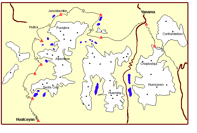
Legend: red triangles=campsites; brown lines=roads; white=glacial cover; black triangles=high peaks; blue=lakes
During the two weeks I trekked there in 1997, I ran into only one other group of hikers. While mountain climbers are regulars here (Huascaran and Alpamayo are climbing favorites, and the sheer number of interesting, high peaks makes this area a climber's Mecca), trekkers are less common, with estimates of less than a dozen organized groups tackling the back country each year.
Cordillera Blanca is a wilderness unlike any others I've encountered. The first surprise is that you'll come over a high mountain pass only to encounter cows and llamas grazing by themselves in the highlands on the far side. Farming tradition in the area is to let animals graze wherever they want, and to only go find and collect the animals when it's time for slaughter or sheering. You don't expect to have to watch out for cow patties in a col at 16,000 feet (4800m), but you'd better be on the lookout when you walk the Cordillera Blanca.
The terrain consists mostly of treeless, shrubless stubble for much of the trek, but the spectacular peaks, glacial lakes, ice flows, and wondrous sunsets soon make up for that. You won't be looking down at the parched land at your feet very often with the countless white gems rising into the sky around you. It's not unusual to find condors sailing along the ridges, but other wildlife is sadly lacking. You'll hear the wind, icefalls, an occasional bird, your labored breathing, and nothing else.
Preparations
The trek described here is only one of many possible routes in the Cordillera Blanca. Wilderness Travel (Berkeley, CA) offers the itinerary every now and again, should you care to go with an organized group. It's also possible to hire local guides familiar with the area in Huaraz, Peru's low-key answer to Katmandu. Shorter hikes are possible in many places along the range. A reasonable trail map by Editorial Universo S.A. is available locally in Huaraz, and several English-speaking outfits in town can help you plan a trip. While trekking supplies are available in Huaraz, most of the equipment I saw there was older and worn—it's best to bring your personal gear.
For longer treks, pack animals carry the necessary supplies and the heavier gear. On the trip described here, resupply is unavailable without significant detour; this would be a very difficult trip to make without using animals.
As with most hikes in the Andes, two factors make this a difficult trip. You're at high altitude throughout this trek. Worse still, every day's route involves significant elevation gain and loss. Altitude sickness is always a factor above 9,000 feet (2700m), and you'll be well above that altitude throughout the described circuit. Therefore, several precautions are in order before tackling the Cordillera Blanca.
First, you need to acclimate. Huaraz is at 10,000 feet (3000m). Spending a few days in this funky, freewheeling little town is definitely in order, perhaps with a few day hikes in the nearby area to get your legs accustomed to the trail. Taking Diamox prophylactically is another precaution you might consider (consult with your doctor first; Diamox requires a prescription in the US). No matter what, drink more fluid than you normally would, avoid alcohol, and learn the symptoms that indicate the beginnings of serious altitude problems (severe headache, coughing due to fluid in lungs, and loss of coordination are three of the more obvious ones).
Second, you need to be prepared for cold. While hiking, you'll generally warm up quickly when the sun is out. Daytime temperatures tend to be in the mid to high 70's, and sun bouncing off snow tends to make it feel warmer. Nights are distinctly cool, however, and even in peak season you should expect subfreezing temperatures on at least a few mornings. Multiple layers of water-wicking clothing is in order, and you'll want to carry a sleeping bag rated to at least 0 degrees, possible lower. Your breath will be heavy with water vapor at night. Down bags could get significantly wet, something you'll want to consider.
Finally, you'll be a long way from medical help. Besides being fit, you'll want to take some reasonable precautions. Make sure your Tetanus booster is up-to-date, carry antibiotics and any other medicine you might need in an emergency, and consider what you might need to do in the case of a serious sprain or bone break. One benefit of traveling with pack animals is that, in an emergency, it's possible to transport someone out with an animal. Still, at best you're two days away from the nearest town with even rudimentary medical facilities. The good news is that insects aren't a problem here, and thus malaria and yellow fever aren't threats about which you have to worry.
Preparations out of the way, it's time to start trekking!
Day 1 -- Up the Hill
From Huaraz, it's a leisurely day's drive to the trailhead near Hualcayan. A number of small towns dot the road alongside the Rio Santa, including the infamous Yungay, a town of 25,000 that was completely buried by a mudslide that came down Huascaran during the 1970 earthquake. The road gets progressively narrower and less traveled as you make your way North, eventually becoming a bumpy, dusty dirt trail as you near the start of the trek. Despite the appearance that you're in the middle of nowhere, your overnight stay at the trailhead will most likely attract a few curious local children.
As already noted, the first day's hike is rough. You must climb out of the last vestiges of the valley and into the Cordillera Blanca itself. The first night's destination is a glacial lake nestled beneath the three peaks of Santa Cruz. It's not a long hike, but it still is the largest one-day elevation gain you'll have to make during the next two weeks. Take your time and enjoy the scenery. At a leisurely rate, you should make it from the trailhead to Lake Cullicacha in six or seven hours. When I was there, the water tested out at 48 degrees, so I won't blame you if forgo a quick swim.
Watch carefully for signs of altitude sickness on this first day. Cullicacha is also the second highest campsite on the trail, and is a good test of your acclimation.
Day 2 & 3 -- Alpamayo
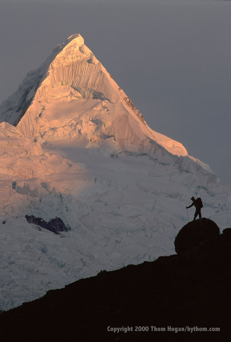
So if you climbed almost 5000 feet (1500m) the first day, guess what you get to do first thing the morning of the second? That's right, climb some more! A modest 800 feet (240m) up a rocky slope takes you to the first of what will be many memorable passes. A quick dip into a small valley is followed by another climb, this time on a scree-filled slope that'll keep you alert. A hiking staff is definitely a welcome addition to your gear, and very useful when you encounter these steep scree slopes. At drop off the scree takes you to a small creek running through a narrow valley. To your left is the 18,000 foot (5400m) Miluacocha, while strait ahead you see the classic pyramid shape of the 19,500 foot (5900m) Alpamayo.
The valley you've entered has views in every direction, and the second day's camp can be set up virtually anywhere. The further up the valley you get, however, the better the view of Alpamayo. Most group treks take an extra day in this area to give you a chance to recover from the early climb, so enjoy the view. Depending upon where you camp, you'll be somewhere between 13,000 feet (3900m) and 13,800 feet (4200m). While that sounds high, it's enough lower than the first night that you'll appreciate the difference. Ambitious types can take a day hike up the backside of Santa Cruz, where you'll find yourself surrounded by nine peaks over 19,000 feet (5700m).
Day 4-- An Easy Pass
Up early again to get up a 15,550 foot (4700m) col between Pilanco and Tayapampa, the hiking begins to get a bit easier after the climb. A gentle grade takes you along another creek to an easy (!) 14,300 foot (4300m) pass. You might begin to notice some interesting cactus ground cover (Huaculo in the local dialect). An occasional farm animal grazes near the trail. Again, several day hikes are possible from your third campsite, in this case up to glacial lakes just behind Jancarurish and Pucajirca, the peaks that tower above you on this day.
Day 5 & 6 -- Jancapampa
Next morning, you start down a gentle trail that eventually becomes a dirt road, which eventually leads to a confluence of three different valleys. Here you'll find the first sign of "civilization." A small peasant's home sits near the intersection, and an alpaca herd often grazes along the edges of the valley. Amazingly, the two or three scattered homes in this area comprise a named village, Huilica. You'll wonder where the village is, but you're standing in it!
The people that live on the periphery of the Cordillera Blanca seldom see outsiders, rarely get to what we'd call a town, and will be as curious about you as you are about them. Yes, the children will sometimes beg ("rebelo por mi", literally "gift for me"), so come prepared. Money isn't useful, and candy is not a good idea in light of the lack of dental care nearby, so bring some small useful treats. One fellow on the trip I took brought pencils and paper, which I thought was an excellent idea (and appeared to be well appreciated).
From Huilica, you'll head up what looks like a dead-end canyon (it is). The climb to the 14,500 foot (4400m) col is made tough by relentless scree on a very steep slope. Worse still, you'll be in the heat of the day when you tackle this climb, so take your time and make sure to keep hydrated. You lose almost 3000 feet (900m) of elevation once you get over this pass, so you have an easy afternoon of hiking ahead of you. Better still, several lakes and waterfalls dot the hillsides as you head down to the next camp. At the bottom, you're finally back below treeline, which provides useful shade in the late afternoon.
The camp you come to next is my favorite on this trail. The guides call the area Jancapampa (the name of the creek that runs from the glaciers at the head of the valley), but the map calls the "village" Pishgopampa. What makes this site so special are the ubiquitous strings of ice that hang off the back side of Pucajirca at the head of the valley. Scattered through the valley are several homes of local Quechuan (pronounced catch-oo-un) families. In one stunning 360 degree vista you have the mountain's full majesty on one side, and a slice of rural Peru living much as it has for hundreds of years on the other. Sunrise and sunset are both special times in this picturesque valley.
During my brief stay in Jancapampa, we were treated to dozens of small children hovering, watching our every movement. As it turned out, we hit the valley on a school holiday, and our trekking group quickly became the village's primary source of entertainment. (A word of warning: anything you leave lying about is considered a "gift" and rapidly disappears.) Fortunately, the valley folk reciprocated and became our entertainment, too. We watched children collecting wood, men plowing fields with oxen, women cooking and cleaning, and were even treated to a demonstration of traditional weaving methods.
Day 7 & 8 -- Pucaraju
From Jancapampa, a gentle climb takes you out of the valley and up to a 13,900 foot (4200m) pass. This day's route is among the easiest, and eventually wanders down to a small lake (Huecruchocha). Camp here was on an exposed ridge with interesting views back down a valley as well as the backside of Pucaraju (16,500 feet, 5000m).
Our goat herders took the opportunity to make a quick 10-mile run down to a local village to pick up some additional food stores. By midmorning, they had caught back up to us as we took our time climbing the pass alongside Pucaraju. Several of us took a short side trip to get closer to a nearby glacier that hung off the side of Tauliraju. This day's camp is another good one to spend an extra day at if you have the provisions and time. Several trails take you up to a half-dozen glacial lakes and a pass where you get a completely different view of the famous Alpamayo profile. Rumor has it that people even ski off this side of Alpamayo and Quitaraju, but it's hard to imagine how you'd get much pleasure out of such a run, as there are no lifts and you must climb several thousand feet of crummy glacial ice for the privilege.
Day 9 -- Civilization!
The longest single-day's mileage comes next (perhaps as much as nine miles). Fortunately, most of the terrain is downhill or rolling hills on the edge of a valley. Today is the one day you'll see lots of people and what you normally think of as a village. If you've been missing Coca-Cola, bear, or candy bars, an opportunity or two to indulge your cravings appears along this section of the trail if you look closely. Eventually, you skirt alongside the only town of note on the trail (Yanama) and start heading uphill back up into the heart of the Cordillera Blanca. Where you camp this night depends upon how much time you lost drinking that Coke and interacting with locals. In general, you want to get as far up the trail as you can, as you're beginning another tough, relentless climb.
Day 10 -- Climbing Again
This last climb takes you between two dramatic ice flows [now very much receded]. Towering to one side is 20,800 foot (6300m) Chopicalqui, while on the other is 19,800 foot (6000m) Contrahierbas. As you begin working the switchbacks, you might begin to wonder whether you're actually going to climb one of these peaks. Since the trail is so severe at this point, your goal for the day is to simply get to a point a few hundred feet below the final pass. Still, this means another 3500 feet (1000m) of vertical over difficult terrain, a hard day for any hiker.
A few years back, the glaciers in this area actually covered the trail, which would have made a tough climb tougher. Today, the glaciers have receded up the slopes. You'll be treated to almost constant icefalls off the southern face of Contrahierbas, however. Your highest camp is here facing the icefalls, which makes for a dramatic and cold night.
Day 11 -- Huascaran!
Only one last day of hiking remains. In the morning, head up to the highest pass on the trek (over 16,000 feet, 4800m) and one of the most unusual. Here you'll find that the trail has been literally cut out of the side of a cliff. Barely wide enough for the pack animals, it's plenty wide for hikers. But if you have a problem with heights, don't look down or back! From the top of the pass almost 6000 vertical feet (1800m) of view awaits you--imagine that you're standing on Half Dome in Yosemite, but the valley floor is over twice the distance below you. The real prize, however, is the sudden view of the backside of Huascaran as you come around the last bit of the pass.
A steep, scree-lined slope makes the descent harder than you'd like it to be, but you're beginning a long drop down into yet another charming valley. A brief stretch takes you through an unusual forest before you hit a flatter stretch leading down to Ulla creek. A few miles down this stretch and you come to a dirt road that is the primary connection between Huaraz and the eastern side of the Cordillera Blanca. If you're lucky, one of the local busses will be puffing its way up and over the 16,000 foot (4800m) Punta Olimpica.
Your ride should be waiting for you at the creek, and by dinner you'll be comfortably back in Huaraz reminiscing over the long, rewarding journey you've just made.
About Huaraz
Huaraz has a population of about 80,000, and is the starting point of any hike into the Cordillera Blanca. Regular bus service is available from Lima, and takes most of a day. Information on hiking the area is also available at the South American Explorers Club in Lima (0051-14-250142). In Huaraz itself, try the Trekking & Backpacking Club at Pasaje Sal y Rosas 358 (Casilla 112), a private information office that can supply maps and hook you up with a guide. You'll also need to pay your park fee (about $1 a day, but subject to change) at the Huascaran National Park Office in the Ministry of Agriculture, which is at the east end of Av Raymondi.
When to Go
Since you're so near the equator, there is no set winter and summer seasons, only wet and dry times. Climbing is usually done in the "dry season" from June to August, and this is regarded at the best trekking season, as well. Be prepared for heavy rain from January through March. Temperatures don't vary much during the year. Expect 60 degree days and subfreezing nights at altitude. The mean temperature in Huaraz (year-round) is only 57 degrees.